This steam engine train ride in San Francisco in 1901 must have been thrilling!
The film is photographed from the front of a moving steam engine and it shows the scenic portion of the Ferries and Cliff House Railroad route along the bluffs and cliffs of Lands End (at the northwest corner of San Francisco) overlooking the Golden Gate and the Marin headlands. The line gave access to the famed Cliff House and Sutro Baths, previously accessed by the Point Lobos toll road through the sand dunes and by a nearby inland railroad.
The railroad was built between 1886-1888
The Ferries and Cliff House line, the youngest and last of San Francisco’s steam railroads (five in all) was built between 1886 and 1888 under the direction of owners W.H. Martin, John Ballard, W.J. Adams, Thomas Magee, and H.H. Lynch. The line was absorbed into the United Railroads of San Francisco in 1894 (owned by the Southern Pacific Railroad) and was served by six light and two heavy Baldwin steam engines, the latter used on Sundays. The rails were of English steel.
The line ceased operation before the 1906 earthquake
Hurt by competition from a rival – and cheaper – inland line owned by former Mayor Adolph Sutro (owner of the Cliff House and Sutro Baths and enemy of the Southern Pacific Railroad), the line ceased operation shortly before the 1906 earthquake. The locomotives were replaced with electric streetcars of the Sutter and California Street Railroad’s #1 line. The streetcars ceased operation after the trackbed was eroded by landslides in 1925.
RIBBON OF LOVE: 2nd edition – A Novel Of Colonial America: Book one in the Tapestry of Love Series
Today the trackbed, partly destroyed by landslides, is a trail in the Lands End unit of the Golden Gate National Recreation Area. Monterey cypress trees and other plants were subsequently introduced and have greatly altered the original coastal shrub landscape.
Passengers could continue by cable car
The film shows the first 1.5 miles of the 5.25 mile eastbound return trip from the Cliff House and Sutro Baths to the train terminal at California Street and Central Avenue (now Presidio Avenue).
From the terminal, passengers could continue by cable car to downtown or to various outlying neighborhoods. The portion of the route not shown was along California Street, through the thinly-developed sand dunes of the Richmond district. The scenic portion was built at an elevation averaging 150 feet, affording superb views of the Golden Gate, the entrance strait to San Francisco Bay.
The following is a scene-by-scene description of the film:
- The train heads just west of north from the Sutro Baths Station, near the Cliff House. [0411] Swinging right (northeast) the camera looks across the water to Marin County and Point Bonita, the northwest entrance of the Golden Gate. Mount Tamalpais rises in the background. The Marin headlands stretch to the right, along the north shore of the Golden Gate. (They are now part of the Golden Gate National Recreation Area.)
- The Narrows, the mile-wide inner mouth of the Golden Gate, and the later site of the Golden Gate Bridge, are visible. The view is northeast. Beyond, in San Francisco Bay, is Angel Island.
- The Presidio occupies the cliff-edged peninsula extending north to the Narrows. Site of 1776 Spanish fort, or presidio, the Presidio became a United States Army base (6th Army Headquarters), and was scheduled to revert to the Golden Gate National Recreation Area in 1995. Below, in the foreground, is the actual Lands End Point. The small adjacent beach was a popular picnic site (and is now a clothing optional beach).
- Rounding a corner, the trail down to Lands End beach comes into view. The small station marks the upper end of the beach trail. Note the advertisements papered on its walls, one touting a popular liniment.
- A sign warns of the approaching entry into the 100 foot tunnel; another sign appears at left. The tunnel became an open cut when the line was converted to streetcars.
- The train exits the tunnel and provides a fine view of the Presidio cliffs and Baker Beach (right). This portion of the trackbed was eroded in 1925, causing closure of the line.
- Deadman’s Point is in the foreground, named years later by Coast Guard rescuers for foolhardy cliff climbers.
- In the distance are white buildings of the Richmond district, south of the Presidio. Partly behind the slope at right is Lone Mountain, then Laurel Hill Cemetery, now part of the University of San Francisco campus.
- Beyond the cut, on the rise at right, are a fence and row of cypress trees marking the northeast corner of the 200-acre City Cemetery (1888-1909, also called Golden Gate Cemetery – now Lincoln Park Golf Course).
- Lone Mountain is again visible beyond the utility pole.
- The camera views the central hills of San Francisco (from left to right): Mount Sutro, Strawberry Hill (in middleground, in Golden Gate Park), Mount Davidson, and Golden Gate Heights.
- A few dwellings are seen along Point Lobos Avenue (now Geary Boulevard) in the left foreground. Behind at right is a partly quarried hill now called Washington Heights (site of Washington High School, 1936).
- Heading due south (in line with today’s 33rd Avenue, to the south), an abandoned windmill (left) and a station inscribed “San Francisco City Cemetery” (right) can be seen.
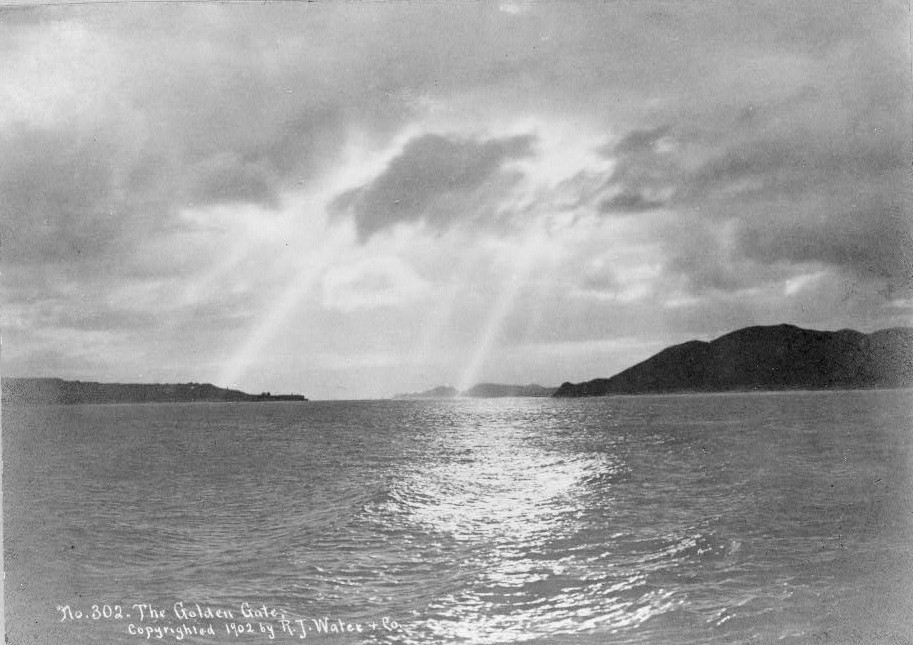
View of the San Francisco Bay before Golden Gate Bridge was built with sun shining through clouds on water.
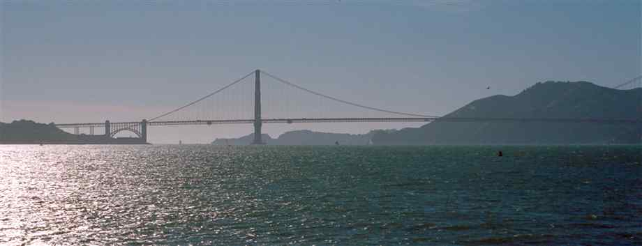
Same view with the Golden Gate bridge in the view today…
Three complete historical novels for $14.97! Tapestry of Love Historical Series 2nd edition 2015 –
Court records dating back to the 1630s create historical accuracy as the reader is taken back to the primitive days of colonial Virginia and Maryland where the Pattendens encounter life-changing difficulties with Indians, ducking stools, illness, massacres, death, loneliness, love, and greed.
FreeHearts: 2nd edition A Novel of Colonial America (Tapestry of Love Series Book 3) Inspired by true events, Col. John Washington (ancestor of President George Washington), Randall Revell, Tom Cottingham, Edmund Beauchamp ward off Indian attacks and conquer the wilds of Maryland’s Eastern shore in 17th century colonial America in this historical novel.
